Nagoya Starwalk Leg 1: North
(March 13, 2015)
The first starwalk leg started at 9:30am on Friday March 13 from the gold clock just inside the Nagoya train station (Sakura Dori side). It finished at 3:42pm after 6 hours and 11 minutes and 16.9 kilometers (10.5 miles) of walking. I took about 380 photos along the way.
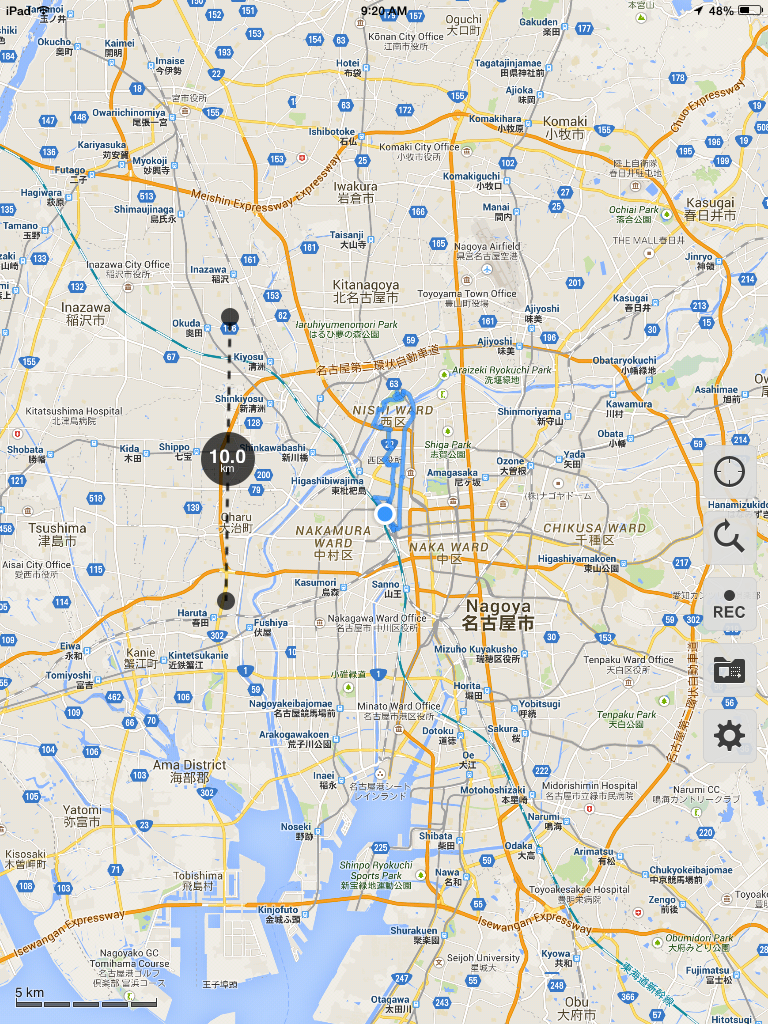
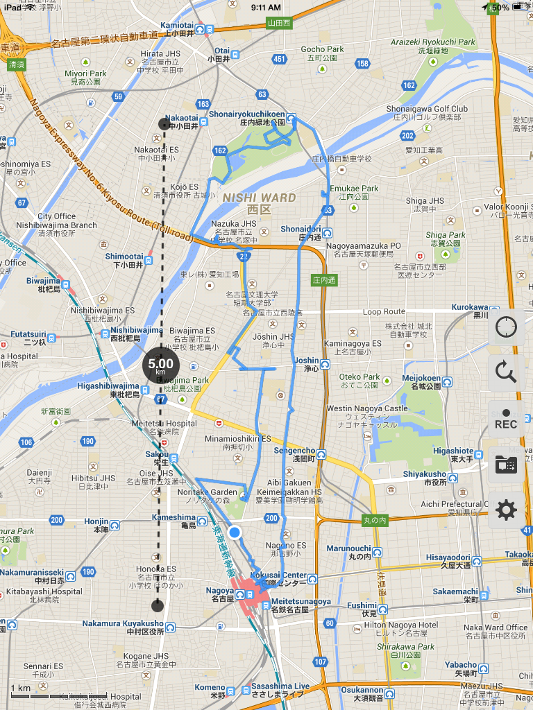
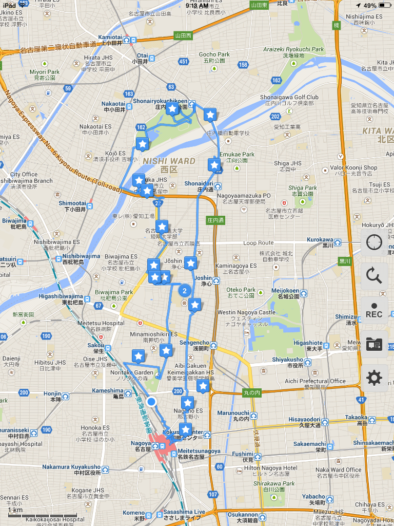
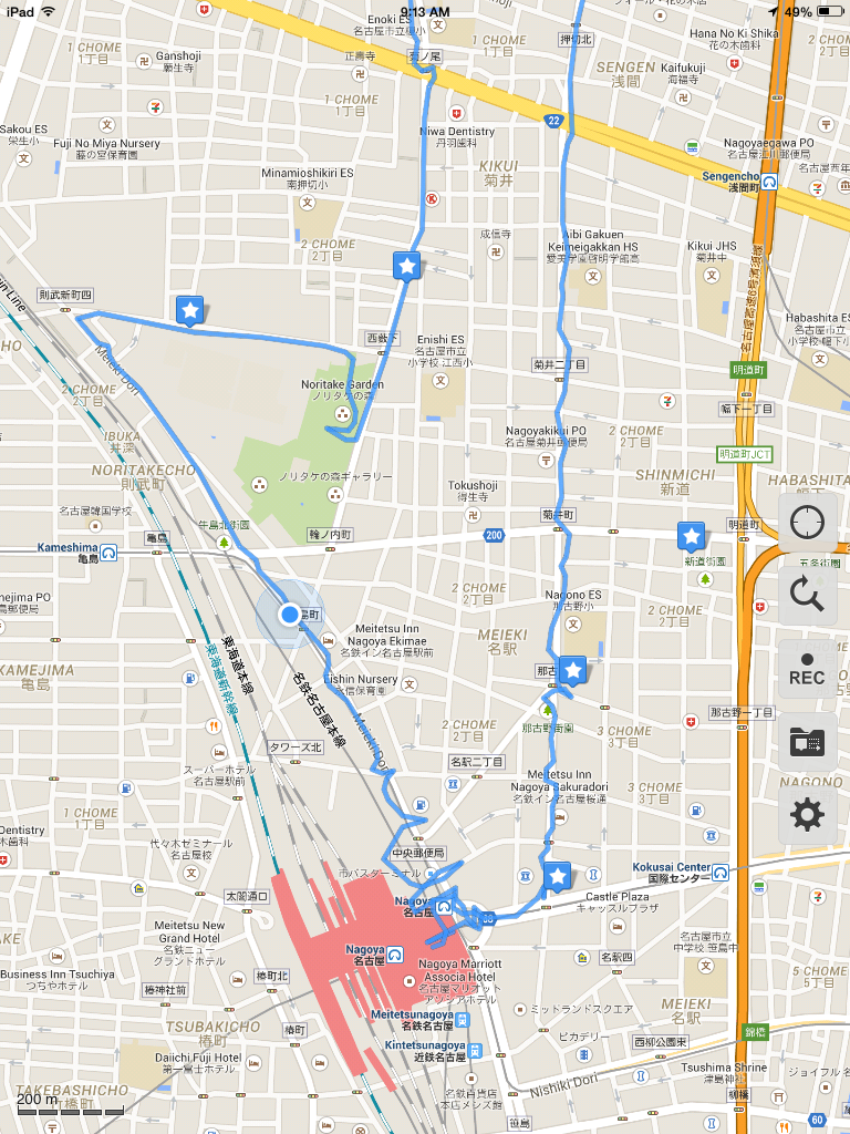
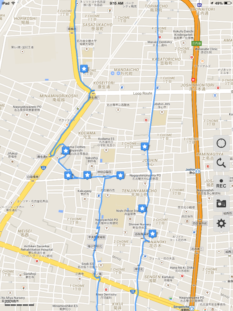
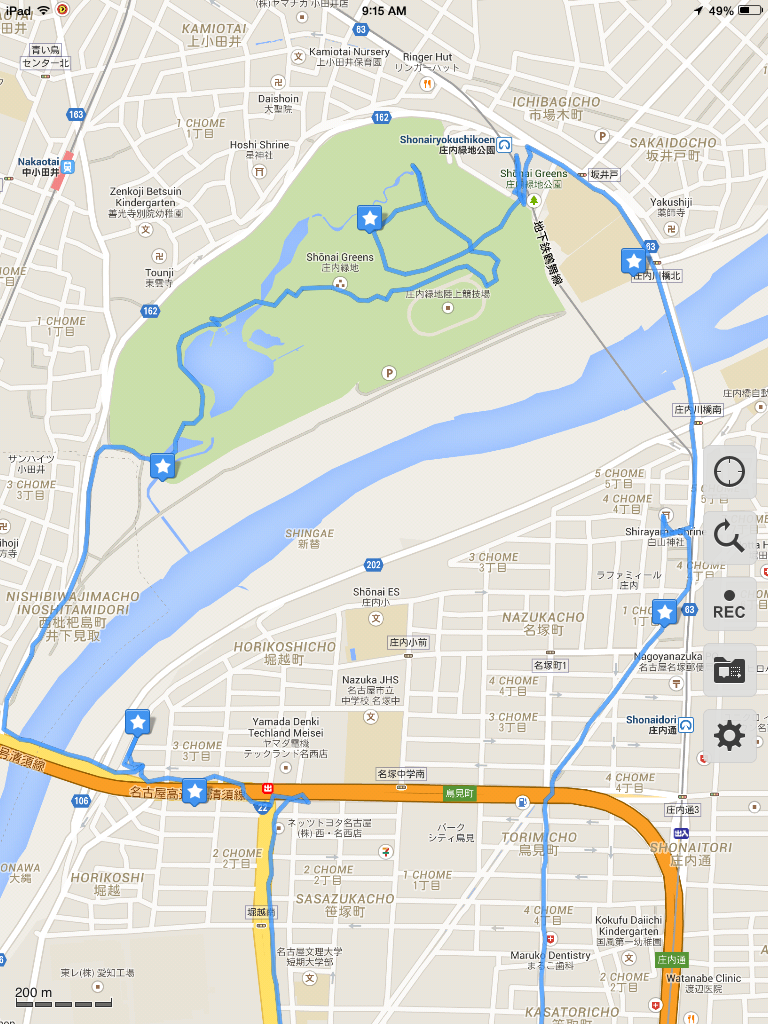
From the gold clock in Nagoya Station I turned east, headed out the door, and across the street. I then checked my compass and headed north. Don't let the track on the map fool you. I did not zig zag that much at the start. There are some very tall buildings right there and they can interfere with GPS signals. I had set my GPS tolerance at 100 meters so no value beyond that would register, but even something within that range could look a bit wild. The track kind of makes me look indecisive, doesn't it.
Rest assured, I walked northward along the east side of Meieki Dori and stayed there. My infallible sense of direction kept me on track for well over 20 meters...and then became less infallible. My trusty $3 compass remained true but it turns out I can be heading in a north-ish direction and still go off track. After I discovered this, I decided that the best thing to do was ignore the compass and regularly check my position on the map in the Galileo Pro tracking app on my iPhone and compare it to Nagoya station. Once I switched to that strategy, the only thing that got me off course was curiosity and geography.
As one might expect, the area around the station is heavily commercial. However, you do find many small shops amid the tall buildings and it doesn't take long before residences and individual houses come into view - including some with classically manicured gardens and some that are incredibly narrow. Photos
I have no regrets about going off course. It's just more area to explore and who knows what you will find. For example, I found the Nagoya Plastic Surgery Clinic and then I found the northern entrance to Noritake Garden. Of course, I went in (to the garden - not the clinic). The garden was looking a little dry grass-wise, but it is still winter here and we even had a light dusting of snow a fews days prior. Further in, I came across the donor recognition wall and the remains of the old kilns. Photos
Back on track, really going north this time, I soon came upon a small shrine. With Google's help, it looks like it is attached to the Jizoin buddhist temple (地蔵院).
I crossed over Kikunoo Dori (Route 22) via a pedestrian overpass and continued north until I reached the post office. Excellent! I could use a bathroom. That miso soup I had with breakfast probably wasn't a good idea. I found the bathroom but it had a sign on it with a lot of words I couldn't read. Probably something like "for employees only..." Too bad, I went in anyway...and...the door lock did not work. Sigh. That was more risk that I was willing to take. Went back out and kept moving north. Luckily, at the beginning of the next block, I found a couple of maps showing that I was right next to a park (Oshikiri Park). The park map shows bathrooms. I'm saved.
Turned right at the next corner and soon found the small lavatory. There has a urinal and an in-floor, old-style Japanese toilet. The urinal is rather breezy (no door to this lavatory) so I opted for the toilet (which did have a door). I read somewhere that some public toilets in Japan do not have any toilet paper. I remembered this and planned accordingly. My planning paid off as there was no TP. There was also no paper towels or anything else to dry your hands after washing them. That I can live with.
Continued walking again with a noticably happier demeaner. Needed to head west for awhile to find a street with a sidewalk. Japanese residential streets are narrow and many of the ones I've seen don't have any sidewalk. That's okay for a short distance but I don't want to do it for blocks and blocks. Photos
More happy discoveries as I headed west: a small bakery named Cheminee and a small restaurant named Hotto Motto. The bakery smells really good but it is small and I didn't see any meron pan (melon bread). I continued walking. The restaurant has a cute name. It looked like it was a chain fast food restaurant serving standard Japanese food.
As I headed northwest toward a main road, I spied something interesting and veered right. It is an impressive childrens play area that includes a shallow-sloped rock climbing wall and a rope pulley among other things. The Japanese really know how to build good playgrounds.
Onto the main road, called Loop Route, and had to backtrack a bit to get to a crosswalk. My wife will be interested to know that I walked right past a Lexus dealership. I did not go in. Crossed the street and headed northerly again until I reached the Kosei Dori 2 intersection. Crossed over using a pedestrian overpass and turned left onto that road (still Route 22). A short distance later I saw some workers installing a new billboard advertising the iPhone 6 and then I found California Gold Pachinko Palace. I did not go in. Photos
Route 22 merged into the Meigi bypass and headed west toward the bridge. As there are only a few bridges across the Shounai River, this was my route. Before I reached the bridge I saw a business across the road called P-Dog. Didn't know what it was at the time but it turns out to be a dog grooming business (dog shampoo). Continued west and I saw a small cemetary. That's worth a detour and I headed over to take a few pictures and then pay my respects.
Once across the bridge I immediately headed north toward a big park, Shounai Greens. Along the way I saw some houses with wonderful blue tile roofs, some with solar water heating. There was also a small fenced area with those large concrete jacks used for shoring up river banks and other erosion-prone areas. I guess they are just pre-staged there for quick access. Photos
At the park I made a great discovery: three fenced-in dog runs - one of which was in use. I've seen dogs here and there. Mostly small dogs (Dachshunds, a Corgi, other small breeds) and a few medium sized dogs (Sheltie). Nothing large. These are the first dog parks I've seen in Japan.
As for the park, at first I thought it might be a golf course given its size on the map and the presence of the lake - but no. It is a very nice, multi-purpose park with a couple of picnic areas, boat rides, a (currently dormant) rose garden, a large playing field (stick hockey?), a few tennis courts, a playground, and plenty of room to sit and/or play. At the center is a clock tower with a statue of a girl perched on its ledge. Photos
By this time it was 1pm and I've gone about as far north as I'm going to get. Time to head home. First, though, sit and have a drink. No surprise that there are some vending machines here and I am pleased to discover that they accept my Manaca card (transit card). No need for cash. Sat for a spell and then headed back. Interestingly, there are some recycle containers for the plastic drink bottles right next to the vending machines. These are the first (and only) "trash" receptacles I saw in the park (didn't look too close at the picnic areas). If you bring it in, I guess you're supposed to pack it out.
The lack of trash cans is true of most places here. I remember on my previous trip to Nagoya in 2012 I bought a take-out lunch at a shop in the train station and then looked in vain for a trash can. Not even the bathrooms had one. I finally went to the tourist information office and asked and, while they did not offer an explanation, they did take my trash off my hands. As I have now lived in Nagoya for over a week, I think I understand why, but I will save that for another post.
Opted to use the lavatory at the park before heading out again. No TP, no paper towels or air dryer for your hands.
I've moved clockwise from the original northerly (ahem) route and there is a nice bridge right there to help me get back across the river. Before I get there I saw a couple of buildings with some large open space behind them. Turns out there are a couple of driving schools there and they have a mini course set up to give people basic skills before taking them out into real traffic. I know we have driving schools in the States but I've never seen any with their own test course. I probably just haven't looked.
Walked across the bridge and a short distance later find a shrine. Apparently this is the site of an old castle (Nazuka Castle) from the 1500's. There is also a small Inari shrine in the back. Photos
After the shrine I was back on a main road but soon decided that a different path might be more interesting. My map showed a street veering off to the southwest and when I got there I was very pleasantly surprised to find that it was a nicely landscaped pedestrian-only path along a modernized creek bed. At the southern point where the walk terminates is a statue of a young girl with (statue) pigeons hovering about her head and hands. There was no sign of any real pigeons. If I think real hard about that it might lead me to something insightful - but it isn't worth it.
I was back on a decent sized street with lots of small businesses. Nothing in particular grabbed my eye until I saw a restaurant across the street with a Tanuki out front. The restaurant's name is Hakata and it serves dishes ala carte That's what 一品料理 (ippinryouri) means. A Tanuki is a Japanese raccoon dog which has the facial mask resembling a raccoon but is more closely related to wolves and foxes (canines).
At a point where I was about parallel with the post office, I spotted dog heads and feet peeking out over a second floor balcony. I think it is some kind of home renovation outfit but don't quote me on that. Anyway, they do offer free estimates.
Further down the road a spell I notice a sign indicating a church. Turned out to be a Konko church (ie, a church of the Konko faith). From their web site: "Konko" means golden light. Also per their web site, there are around 1,500 Konko churches in Japan. They are definitely not a Christian church and I had never heard of them before.
At a large intersection, I spotted a Balloon and Toy Store off to the east. It was too far off my path to go check out but I note it here for possible future investigation.
Back into the thick of downtown, I see a fire truck parked outside a building. Turns out to be Emergency Task Force 2. Other than fire and probably paramedic work, I'm not sure what else an "emergency task force" does. Perhaps act as a command center in case of disaster?
Turned the last corner and the train station was in sight (actually it is hard to miss the tall towers). On the corner is my last marker, a downtown bookstore named Junkudo. I did not go in. As you may have noticed, there wasn't a whole lot that caught my eye in the last few kilometers. Fatigue had set in and I was ready to be home.
I finally made it back to the gold clock inside the station. It was 3:42pm, I'd walked 16.9 kilometers (10.5 miles) in 6 hours and 11 minutes and had a fascinating time. Back to the apartment for a breather. I planned to celebrate that night by going out for dinner (there was nothing left in the fridge). Of course, I had to walk to get there...ugh. Photos